|
Historical background to the boundary disputes been Persian and Ottoman empires
The Iran-Iraq boundary can be viewed as unique within the Middle East region. The morphology of the border landscape is certainly much more varied than the desert through which many of the geometric boundary lines of the Arabian Peninsula have been drawn. From north to south, the most recently agreed delimitation (1975) utilises a number of high drainage divides in Kurdistan, continues along the western edge of the Zagros mountains and then crosses a broad, alluvial plain to the Shatt al Arab, where for its last sixty-five miles the boundary assumes a course along the Thalweg. More significantly the Iran-Iraq boundary has long displayed the classic characteristics of a political frontier-zone or a border march. This contrasts sharply with the twentieth-century framework imposed largely by European colonial powers elsewhere in the Middle East. Imperial conflict over the Zagros mountains and the Mesopotamian plain was an ancient phenomenon. In pre-Islamic times this east-west configuration could be observed when the Persian and Greek empires hired Christian Arab groups from the Hira and Damascus respectively to fight out their own wars. Essentially beginning with the series of conflicts inaugurated by Sultan Selim I in 1514, the Sunni Ottoman Empire and the Shi´a Persian Safavid Dynasty clashed repeatedly in their efforts to impose their respective creeds of Islam upon the Zagros-Mesopotamia region. Second Treaty of Erzeroum (1847) For the period under review three principal phases of diplomatic activity have shaped the course of the Iran-Iraq boundary. Each has resulted in the signature of treaties defining or modifying the boundary, in 1847, 1913, and 1937 respectively. The second Treaty of Erzeroum of 1847 and its Explanatory Note of 1848 were the culmination of four years of intense negotiations between the British, Russians, Ottomans and Persians. The land boundary was allocated for its entire length while further south a territorial limit was rather loosely defined along the east bank of the Shatt al Arab river. Reference to the nineteenth century documentation in the volumes, which include substantial sections of the original, handwritten diary of the Turco-Persian Boundary Commission, will highlight the massive problems encountered in precisely establishing the Perso-Ottoman divide. The complete distaste for compromise shown by the Persians and Ottomans led an exasperated and impatient British Foreign Secretary, Lord Palmerston, to comment in 1851 that "the boundary line between Turkey and Persia can never be finally settled except by an arbitrary decision on the part of Great Britain and Russia". The Constantinople Protocol (1913) In the Tehran Protocol of December 1911, Persia and the Ottomans agreed that a new delimitation commission should commence work based on the clauses of the 1847 treaty. During 1912, eighteen meetings provided no tangible results. However, mediating powers of Britain and Russia worked energetically behind the scenes in pressing for a new settlement to resolve all outstanding difficulties. Instead of the dispute being referred to the Hague Court of Arbitration, Britain induced ´the sick man of Europe´ (the Ottoman Empire) to agree to a boundary line in July 1913. Further quadripartite negotiations resulted in the signature of the Constantinople Protocol of November 1913, when the delimitation was clarified in considerable detail. In 1914, as the immense detail of the Procès-verbaux illustrates, the boundary was demarcated by pillar. As head of the British survey team Charles was a key player in the tense record of these developments. A spate of very useful printed Foreign Office memoranda appeared around this time, familiarising Whitehall personnel with the nineteenth century history of the border dispute. The Tehran Treaty (1937) Relations between Iran and Iraq soured over the Shatt al Arab in the early 1930s. Accusations and counter-accusations of border violations were made with increasing frequency and both sides argued the boundary issue in an inconclusive hearing before the League of Nations in 1934-35. The Saadabad Pact regional security agreement between Turkey, Iran, Iraq and Afghanistan was signed in Tehran in July 1937. After two and a half years of exhaustive and often fruitless negotiations, Iran and Iraq took this same opportunity to sign a further boundary treaty. This extended Iranian sovereignty to the Thalweg over a stretch of water alongside Abadan anchorage but otherwise confirmed the validity of the earlier 1847 and 1913 treaties. The Iraqi revolution of 1958 ended Britain´s intimate and continuous involvement in the development and administration of the Iran-Iraq border and the documentation ends at this point. |
Charles was appointed as the senior surveyor for the British working with the Commissioner and his Deputy alongside Russian colleagues and with representatives of the Turkish and Persian governments. They were to arbitrate over disputes before erecting boundary pillars. Below are links to his letters and to his lecture to the RGS.
When Turkey entered the First World War just as the survey work was nearing completion, Charles had to make his way back to England via Russia and then by sea from Archangel and round the North Cape. 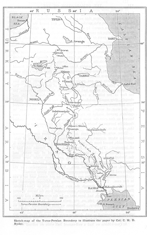
|
